Geolocate

Tara topographic map

Click on the map to display elevation.

About this map

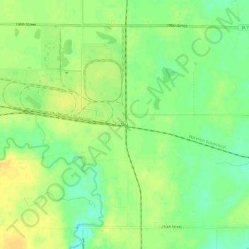
Name: Tara topographic map, elevation, terrain.

Location: Tara, Douglas Township, Webster County, Iowa, United States (42.48025 -94.31580 42.52025 -94.27580)

Average elevation: 347 m

Minimum elevation: 332 m

Maximum elevation: 359 m

Other topographic maps

Click on a map to view its topography, its elevation and its terrain.

Fort Dodge

United States > Iowa > Webster County

Average elevation: 334 m

Duncombe

United States > Iowa > Webster County

Average elevation: 337 m

Badger

United States > Iowa > Webster County

Average elevation: 345 m

Taylor Island

United States > Iowa > Webster County

Average elevation: 328 m

Moorland

United States > Iowa > Webster County

Average elevation: 347 m

Callender

United States > Iowa > Webster County

Average elevation: 349 m

Fort Dodge

United States > Iowa > Webster County

Average elevation: 334 m

Badger

United States > Iowa > Webster County > Badger

Average elevation: 345 m

Gowrie

United States > Iowa > Webster County

Average elevation: 347 m

Moorland

United States > Iowa > Webster County

Average elevation: 347 m

Gear up for your next adventure:

🚲Heavy Duty Bike Lock - Secure your bike at the trailhead or during stops
🥾Trail Running Shoes - Lightweight and durable shoes for trail running
🥾Hiking Leggings - Comfortable leggings for outdoor activities
🧥Insulated Jacket - Keep warm in cold outdoor conditions
🥾Waterproof Hiking Boots - Boots keeping your feet dry in wet conditions

As an Amazon Associate, this site earns from qualifying purchases at no extra cost to you.