Geolocate

Northeast topographic map

Click on the map to display elevation.

Northeast

The northern part junction with Vietnam-China border are the plateau (highland) turns from west to east are: Bắc Hà, Quản Bạ, Đồng Văn. Two first plateau has an average elevation of 1000-1200m. Đồng Văn Plateau is 1600m. Rivers and streams flowing through the plateau created long and deep canyons. There are also some small plains, like Thất Khê, Lạng Sơn, Lộc Bình, and Cao Bằng.

Wikipedia (CC-BY-SA 3.0)

About this map

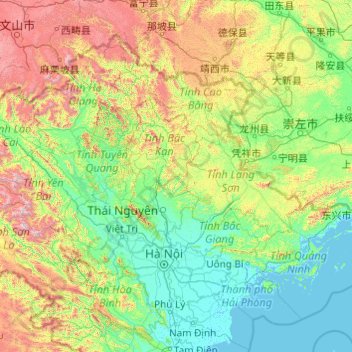
Name: Northeast topographic map, elevation, terrain.

Location: Northeast, Vietnam (20.46463 104.33434 23.39269 108.22329)

Average elevation: 464 m

Minimum elevation: -2 m

Maximum elevation: 2,854 m

Other topographic maps

Click on a map to view its topography, its elevation and its terrain.

Thạnh Lộc

Vietnam > Cần Thơ

Average elevation: 3 m

Cần Thơ

Vietnam > Can Tho City

Average elevation: 3 m

Đồng Hới

Vietnam > Quang Binh province > Đồng Hới > Đồng Hới

The city has diverse topographical and geological features, including hill, mountainous, half mountainous, coastal plains and coastal sand dunes.

Average elevation: 53 m

Phú Hộ

Vietnam > Phu Tho Province > Pho Tho Town > Phú Hộ

Average elevation: 38 m

Di An

Vietnam > Binh Duong province > Di An City > Di An

Average elevation: 12 m

Phú Thọ

Vietnam > Ninh Thuan province

Average elevation: 2 m

Gear up for your next adventure:

🔥Camping Stove - Portable stoves to cook outdoors with ease
🧢Sun Hat - Wide-brim hat for sun protection
🧊Portable Cooler - Keep food and drinks cold during outdoor adventures
🥾Trail Running Boots - Durable shoes designed for trail running
🥾Approach Shoes - Shoes designed for climbing approaches and rugged trails

As an Amazon Associate, this site earns from qualifying purchases at no extra cost to you.