Geolocate

Brigton topographic map

Click on the map to display elevation.

About this map

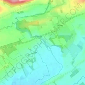
Name: Brigton topographic map, elevation, terrain.

Location: Brigton, Ruthven, Angus, Scotland, PH12 8RG, United Kingdom (56.60373 -3.17570 56.64373 -3.13570)

Average elevation: 67 m

Minimum elevation: 35 m

Maximum elevation: 165 m

Gear up for your next adventure:

🏃Hydration Running Vest - Carry water and maps close to your body for speed
🧢Outdoor Visor - Breathable visor for sunny hikes
Camping Essentials - All-in-one gear for a comfortable camping trip
🦯Trekking Poles - Reduced impact on joints for steep topographic climbs
🧳Compression Sacks - Maximize space in your backpack by shrinking gear

As an Amazon Associate, this site earns from qualifying purchases at no extra cost to you.