Geolocate

Nawla topographic map

Click on the map to display elevation.

About this map

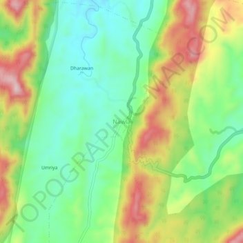
Name: Nawla topographic map, elevation, terrain.

Location: Nawla, Jhadol Tehsil, Udaipur, Rajasthan, India (24.15919 73.29226 24.19919 73.33226)

Average elevation: 585 m

Minimum elevation: 459 m

Maximum elevation: 779 m

Other topographic maps

Click on a map to view its topography, its elevation and its terrain.

Jhadol

India > Rajasthan > Jhadol Tehsil

Average elevation: 607 m

Mahadevji Ka Kad

India > Rajasthan > Jhadol Tehsil

Average elevation: 577 m

Kundal

India > Rajasthan > Jhadol Tehsil > Kundal

Average elevation: 667 m

Kunda

India > Rajasthan > Jhadol Tehsil

Average elevation: 507 m

Kherad

India > Rajasthan > Jhadol Tehsil

Average elevation: 542 m

Kanakpura

India > Rajasthan > Jhadol Tehsil

Average elevation: 556 m

Gear up for your next adventure:

🧦Crew Hiking Socks - Comfortable socks for long-distance hikes
🩹Moleskin Blister Pads - Direct protection for painful foot pressure points
🧥Waterproof Jacket - Lightweight rain jackets for hiking and outdoor activities
🔥Emergency Fire Starter - Reliable ignition source for all weather conditions
🔪Outdoor Multitool - Versatile tool for repairs and food prep in the wild

As an Amazon Associate, this site earns from qualifying purchases at no extra cost to you.