Geolocate

Kundal topographic map

Click on the map to display elevation.

About this map

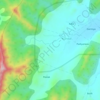
Name: Kundal topographic map, elevation, terrain.

Location: Kundal, Jhadol Tehsil, Udaipur District, Rajasthan, India (24.50093 73.28852 24.52253 73.32717)

Average elevation: 667 m

Minimum elevation: 557 m

Maximum elevation: 994 m

Gear up for your next adventure:

🧢Outdoor Cap - Protective cap for sun and rain during hikes
🛏️Camping Sleeping Mat - Comfortable mats for sleeping outdoors
🏃Hydration Running Vest - Carry water and maps close to your body for speed
💡Compact LED Flashlight - Powerful and portable flashlight for outdoor use
🧦Hiking Liner Socks - Thin base layer to prevent friction and blisters

As an Amazon Associate, this site earns from qualifying purchases at no extra cost to you.