Geolocate

Patcham topographic map

Click on the map to display elevation.

About this map

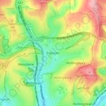
Name: Patcham topographic map, elevation, terrain.

Location: Patcham, Brighton and Hove, England, BN1 8QF, United Kingdom (50.84348 -0.16589 50.88348 -0.12589)

Average elevation: 98 m

Minimum elevation: 29 m

Maximum elevation: 189 m

Other topographic maps

Click on a map to view its topography, its elevation and its terrain.

Brighton

United Kingdom > England > Brighton and Hove

Average elevation: 64 m

Hove Park

United Kingdom > England > Brighton and Hove > Hove

Average elevation: 53 m

Hove

United Kingdom > England > Brighton and Hove

Average elevation: 54 m

BN2 4PG

United Kingdom > England > Brighton and Hove > Brighton

Average elevation: 93 m

BN2 0QU

United Kingdom > England > Brighton and Hove > Brighton

Average elevation: 44 m

Gear up for your next adventure:

🧢Outdoor Visor - Breathable visor for sunny hikes
🦌Outdoor Trail Camera - Monitor wildlife activity near your favorite spots
🥾Hiking Boots - Sturdy boots providing ankle support and traction on rugged trails
🧼Travel Hand Sanitizer - Keep hands clean when water is scarce
🥾Trail Hiking Shoes - Durable shoes designed for rugged trails

As an Amazon Associate, this site earns from qualifying purchases at no extra cost to you.