Geolocate

Gröninge topographic map

Click on the map to display elevation.

About this map

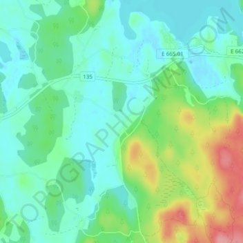
Name: Gröninge topographic map, elevation, terrain.

Location: Gröninge, Kinda kommun, Östergötland County, Sweden (57.89182 15.87919 57.93182 15.91919)

Average elevation: 109 m

Minimum elevation: 83 m

Maximum elevation: 180 m

Other topographic maps

Click on a map to view its topography, its elevation and its terrain.

Kinda kommun

Sweden > Östergötland County

Average elevation: 133 m

Nässja

Sweden > Östergötland County

Average elevation: 91 m

Navestad

Sweden > Östergötland County > Norrköping

Average elevation: 34 m

Vadstena

Sweden > Östergötland County

Average elevation: 98 m

Illern

Sweden > Östergötland County > Linköping

Average elevation: 72 m

Mjölby kommun

Sweden > Östergötland County

Average elevation: 123 m

Halgen

Sweden > Östergötland County

Average elevation: 88 m

Lindö

Sweden > Östergötland County > Lindö

Average elevation: 8 m

Järstad

Sweden > Östergötland County

Average elevation: 82 m

Boxholms kommun

Sweden > Östergötland County

Average elevation: 169 m

Gear up for your next adventure:

🛶Waterproof Dry Bags - Keep electronics and clothes dry during river crossings
📷Outdoor Action Camera - Capture high-elevation views and rugged adventures
🗺️Topographic Maps - Detailed maps to explore trails, mountains, and wilderness areas
🥤Collapsible Travel Cup - Saves space and weight in your mess kit
💡Portable Camping Lamp - Rechargeable lamp for campsite lighting

As an Amazon Associate, this site earns from qualifying purchases at no extra cost to you.