Geolocate

Eastern Visayas topographic map

Click on the map to display elevation.

About this map

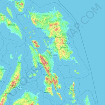
Name: Eastern Visayas topographic map, elevation, terrain.

Location: Eastern Visayas, Philippines (9.76033 123.89919 12.82943 126.10665)

Average elevation: 43 m

Minimum elevation: -2 m

Maximum elevation: 1,253 m

Other topographic maps

Click on a map to view its topography, its elevation and its terrain.

Quezon City

Philippines

Founded as a pueblo by Saint Pedro Bautista in 1590, San Francisco del Monte may be considered Quezon City's oldest district. The original land area of the old town of San Francisco del Monte was approximately2.5 square kilometres (1.0 sq mi) and covered parts of what is currently known as Project 7 and 8 and…

Average elevation: 57 m

Legazpi

Philippines > Albay

Legazpi's topography is generally plain on the northeastern areas, with slopes ranging from five to fifteen degrees. The southern areas have mostly rolling to hilly terrain. In the city's coastal areas, the terrain varies from plain (north) to hilly (south). Legazpi is criss-crossed by several rivers including…

Average elevation: 150 m

Norzagaray

Philippines > Bulacan

Average elevation: 66 m

Antipolo

Philippines > Rizal

Its higher elevation than that of Metro Manila affords it a scenic view of the metropolis, especially at night. Its locally grown mangoes and cashews are popular among tourists, as well as suman – a local delicacy made out of glutinous rice. The Hinulugang Taktak National Park, which was once a popular…

Average elevation: 125 m

Cebu

Philippines

Average elevation: 89 m

Cabadbaran

Philippines > Agusan del Norte

It is 29 kilometres (18 mi) from Butuan. It is generally flat with rolling hills and swamplands in its western part. The highest of all mountains in the Caraga region, Mount Hilong-Hilong (with an altitude of 2,012 metres (6,601 ft) above sea level), rises in this city.

Average elevation: 179 m

Baguio

Philippines

In 1903, Filipinos, Japanese and Chinese workers were hired to build Kennon Road, the first road directly connecting Baguio with the lowlands of La Union and Pangasinan. Before this, the only road to Benguet was Naguilian Road, and it was largely a horse trail at higher elevations. Camp John Hay was…

Average elevation: 881 m

Butuan

Philippines

Average elevation: 115 m

Rizal

Philippines

Average elevation: 95 m

Malolos

Philippines > Bulacan

Malolos is relatively flat of about 0.81% to a gently sloping of 2.17%. The slope of the land descends towards west, southwest to southern direction. The highest land elevation is at about 6.0 meters above sea level while the lowest is only half a meter below sea level. A network of natural waterways and…

Average elevation: 6 m

Meycauayan

Philippines > Bulacan

Average elevation: 27 m

Iligan

Philippines

Average elevation: 229 m

San Juan

Philippines

"San Juan" is a contraction of the city's traditional name of "San Juan del Monte" (lit. 'Saint John of the Mountain'). As with numerous other places in the Philippines, the name combines a patron saint and a toponym; in this case Saint John the Baptist with the locale's hilly terrain and relatively higher…

Average elevation: 35 m

Parañaque

Philippines

Average elevation: 14 m

Silago

Philippines > Southern Leyte

Average elevation: 106 m

Romblon Island

Philippines > Romblon

Average elevation: 43 m

Lapu-Lapu

Philippines

Average elevation: 93 m

Zamboanga City

Philippines > Zamboanga Peninsula > Zamboanga City

The overall topography of the city could be described as rolling to very steep. There are some flat lands, mostly narrow strips along the east coast. The urban center is mostly flat with a gentle slope to the interior, ranging from 0 to 3%. The highest registered elevation is 1,200 metres. In terms of slope, a…

Average elevation: 83 m

Valenzuela

Philippines

The highest elevation point is 38 meters (125 ft) above sea level. Having a surface gradient of 0.55% and a gentle slope, hilly landscape is located in the industrial section of the city in Canumay. The average elevation point is 2 meters (6.6 ft) above sea level.

Average elevation: 24 m

Echague

Philippines > Isabela

Average elevation: 71 m

Bacolod

Philippines

Bacólod (English: Bacolod), is derived from bakólod (Old Spelling: bacólod), the Old Hiligaynon (Old Ilonggo) (Old Spelling: Ylongo and Ilongo) word for a "hill, turtle, mound, rise, hillock, down, any small eminence or elevation", since the resettlement was founded on a stony, hilly area, now the barangay…

Average elevation: 49 m

Mandaluyong

Philippines

Another claims that the Spaniards named the place based on the report of a navigator named Acapulco, who saw the rolling hills frequently being lashed at by daluyong (“big waves from the sea”). This seems to confirm traditional pre-Hispanic stories that giant waves from the sea would meet the adjoining…

Average elevation: 33 m

Cebu City

Philippines > Cebu > Cebu City

Average elevation: 140 m

San Fernando

Philippines > Pampanga

Average elevation: 24 m

Manuel Guianga

Philippines > Davao City

Average elevation: 527 m

Sevilla

Philippines > Bohol

Average elevation: 156 m

Bauang

Philippines > La Union

Average elevation: 40 m

Tagbilaran

Philippines > Bohol

Average elevation: 35 m

Sorsogon City

Philippines > Sorsogon

Sorsogon City covers a land area of 31,292 hectares (120.82 sq mi). It is at the southernmost tip of the Bicol Peninsula and of Luzon Island. The city is bounded by Castilla in the west, Manito in the northwest, Albay Gulf in the north, Prieto Diaz in the east, Gubat in the southeast, Casiguran in the…

Average elevation: 89 m

Iriga

Philippines > Camarines Sur

Average elevation: 115 m

Tuao

Philippines > Cagayan

Average elevation: 58 m

Buguey

Philippines > Cagayan

Average elevation: 1 m

Tukuran

Philippines > Zamboanga del Sur

Average elevation: 35 m

Mananga River

Philippines > Cebu > Talisay

Average elevation: 17 m

Batanes

Philippines

Average elevation: 26 m

Samar

Philippines

Average elevation: 38 m

North Cotabato

Philippines > North Cotabato

Average elevation: 125 m

San Miguel

Philippines > Bulacan

Average elevation: 22 m

Minglanilla

Philippines > Cebu

Average elevation: 61 m

Aparri

Philippines > Cagayan

Average elevation: 1 m

Pilar

Philippines > Bataan

Average elevation: 9 m

Subic

Philippines > Zambales

Average elevation: 46 m

Sison

Philippines > Pangasinan

Average elevation: 124 m

Dagupan

Philippines > Pangasinan

Average elevation: 12 m

Marikina

Philippines

Average elevation: 80 m

Guadalupe

Philippines > Cebu

Average elevation: 61 m

Malainen Luma

Philippines > Cavite > Naic

Average elevation: 54 m

Taguig

Philippines

Average elevation: 39 m

Pasig

Philippines

Average elevation: 46 m

Daraga

Philippines > Albay

67.3% of the total municipal land area has a predominantly low elevation of up to 100 metres (330 ft). The surface terrain is generally characterized by combination of level to nearly level areas, gentle to undulating areas and undulating to rolling areas.

Average elevation: 76 m

Pasay

Philippines

Average elevation: 14 m

Calumpang

Philippines > Bulacan > San Miguel

Average elevation: 41 m

San Isidro

Philippines > Albay > Santo Domingo

Average elevation: 62 m

O'Donnell

Philippines > Tarlac > Capas

Average elevation: 128 m

Minalin

Philippines > Pampanga

Average elevation: 4 m

Kalumala Heights

Philippines > Batangas > Bauan > Sinala

Average elevation: 104 m

Bulusan

Philippines > Sorsogon

Average elevation: 88 m

Tamacan

Philippines > Cavite > Amadeo

Average elevation: 293 m

Tua

Philippines > Cavite > Magallanes

Average elevation: 269 m

Naujan

Philippines > Oriental Mindoro

Average elevation: 4 m

Bakakeng Norte

Philippines

Average elevation: 1,379 m

Nueva Vizcaya

Philippines

Average elevation: 107 m

San Jose del Monte

Philippines > Bulacan

The elevation of the city ranges from approximately 40 to 900 meters (130 to 2,950 ft) above sea level; the relief transitions from warm lowland to cool upland as one goes eastward. This is because the city is part of the Sierra Madre mountain range. Plains and river valley flats characterize the western and…

Average elevation: 103 m

Mount Pinatubo

Philippines > Zambales

Even before the 1991 eruption, Mount Pinatubo had little topographic prominence: it was 1,745 m (5,725 ft) above sea level, only about 600 m (2,000 ft) above nearby plains, and only about 200 m (660 ft) higher than surrounding peaks, which largely obscured it from view. It is part of a chain of volcanoes which…

Average elevation: 1,047 m

Bonga

Philippines > Albay > Bacacay

Average elevation: 162 m

Santa Maria

Philippines > Bulacan

The topography of Santa Maria is generally flat, however, it is becoming hilly towards the north. This area covers the barangays of Silangan, Mag-asawang Sapa, Pulong Buhangin and some parts of Balasing with landscape ranging from 8 to 18 percent slope. The rest of the barangays have a slope range from level…

Average elevation: 18 m

Alfonso

Philippines > Cavite > Alfonso

Average elevation: 413 m

Mandaue

Philippines

It is one of the two (the other one being the municipality of Consolacion) local government units located within the mainland Metro Cebu where the elevation of land is less than 100 m (330 ft).

Average elevation: 109 m

Tanay

Philippines > Rizal

Average elevation: 32 m

Limay

Philippines > Bataan > Limay

Average elevation: 42 m

Valencia

Philippines > Bukidnon

The city's topography is characterized as flat to undulating hills with extensive plateaus and mountainous areas and cliffs on both eastern and western portions bounding the municipality of San Fernando on the east and the municipality of Talakag on the west. Its highest point is Mount Kalatungan in the…

Average elevation: 566 m

Gingoog

Philippines > Misamis Oriental > Gingoog > Gingoog

Average elevation: 461 m

Oton

Philippines > Iloilo > Oton

Average elevation: 6 m

Janiuay

Philippines > Iloilo

Santo Tomas approximate population is 500–800. Santo Tomas (Pakol to locals) is bounded by Madong in the east, Mangil in the north-east and Danao in the south west. It is accessible by three class C feeder roads in the east, south-west and south-east. Agriculture centers around rice, corn, coffee, beans,…

Average elevation: 82 m

Tagaytay

Philippines > Cavite

The southern and eastern portions of Tagaytay are covered by hills and mountains which is generally forests, pine trees and open grasslands. The city lies along Tagaytay Ridge, a ridge stretching about 32 kilometres (20 mi) from Mount Batulao in the west to Mount Sungay in the east with elevations averaging…

Average elevation: 229 m

Impasugong

Philippines > Bukidnon > Impasugong

Cool and moist throughout the year due to its high elevation ranging from 500 metres (1,600 ft) to more than 1,000 metres (3,300 ft) above sea level. It is a typhoon-free area ideal for the production of high value crops. Average temperature ranges from 16 to 31 °C (61 to 88 °F) throughout the year.

Average elevation: 613 m

Banisilan

Philippines > Cotabato

Average elevation: 392 m

Concepcion

Philippines > Pampanga > Mexico

Average elevation: 14 m

Cainta

Philippines > Rizal

Average elevation: 24 m

Dipolog

Philippines > Zamboanga del Norte

Average elevation: 40 m

Santa Cruz

Philippines > Ilocos Sur

Average elevation: 15 m

Culaba

Philippines > Biliran

Average elevation: 124 m

Pototan

Philippines > Iloilo

Average elevation: 24 m

Maco

Philippines > Davao de Oro

Average elevation: 84 m

Mercedes

Philippines > Camarines Norte

Average elevation: 3 m

Badian

Philippines > Cebu

Average elevation: 113 m

Davao City

Philippines

Average elevation: 65 m

Dau

Philippines > Pampanga

Average elevation: 100 m

Macasandig

Philippines

Average elevation: 42 m

Palawan

Philippines

Average elevation: 9 m

Zamboanga del Sur

Philippines

Average elevation: 118 m

Mambusao

Philippines > Capiz

Average elevation: 21 m

Isabela

Philippines

Average elevation: 100 m

Kabugao

Philippines > Apayao

Average elevation: 245 m

Tabaco

Philippines > Albay

The City of Tabaco is located on the eastern coast of Albay province with an area of 117.14 km2 (45.23 sq mi). The terrain in the poblacion or town center of Tabaco is generally flat with the highest elevation at around 5 m (16 ft). The northwestern portion reaches 400 m (1,300 ft) above sea level. The city's…

Average elevation: 182 m

Mount Matutum

Philippines > South Cotabato > Tupi

Mount Matutum is an active stratovolcano, is the highest point in the province of South Cotabato in the Philippines, with an elevation of 7,500 feet (2,286 metres) above sea level, approximately 5.7 kilometres (3.5 mi) from Acmonan, Tupi, South Cotabato. Matutum and its foothills are predominantly inhabited by…

Average elevation: 1,659 m

Tublay

Philippines > Benguet

According to the Philippine Statistics Authority, the municipality has a land area of 102.55 square kilometres (39.59 sq mi)  constituting 3.70% of the 2,769.08-square-kilometre- (1,069.15 sq mi) total area of Benguet. The topography is generally mountainous with an elevation of 1,400 metres (4,600 ft) above…

Average elevation: 1,256 m

Laoag

Philippines > Ilocos Norte > Brgy. 13

Average elevation: 48 m

Carcar

Philippines > Cebu

The land is generally level with less than 18% slope comprising 78.7% of the total land area. Areas with slopes ranging from 18 to 50% cover 19.3% of the total land area and those over 50% slope comprise approximately 1.9%. The highest recorded elevation is a little over 660 metres (2,170 ft) above sea level,…

Average elevation: 97 m

General Tinio

Philippines > Nueva Ecija

Farming is the livelihood of majority of the residents. Even though located at the foot of the Sierra Madre Mountain Ridges, the topography is generally plain ideal to agricultural products such as palay and vegetables. A number of poultry broiler contract growers are located in the municipality. Other…

Average elevation: 54 m

Gear up for your next adventure:

🥾Hiking Leggings - Comfortable leggings for outdoor activities
🥽Outdoor Goggles - Protective eyewear for outdoor activities
🪑Insulated Seat Pad - Protect your seat from cold rocks and wet logs
🛰️Satellite Messenger - Emergency communication for areas with no cell service
🔦LED Flashlight - Powerful and long-lasting flashlight for camping and emergencies

As an Amazon Associate, this site earns from qualifying purchases at no extra cost to you.