Geolocate

Eitzen topographic map

Click on the map to display elevation.

About this map

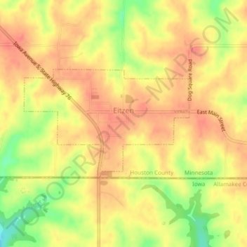
Name: Eitzen topographic map, elevation, terrain.

Location: Eitzen, Houston County, Minnesota, United States (43.50067 -91.47653 43.51254 -91.45154)

Average elevation: 342 m

Minimum elevation: 301 m

Maximum elevation: 363 m

Other topographic maps

Click on a map to view its topography, its elevation and its terrain.

Yucatan

United States > Minnesota > Houston County

Average elevation: 282 m

Wilmington

United States > Minnesota > Houston County

Average elevation: 355 m

Sheldon

United States > Minnesota > Houston County

Average elevation: 298 m

South Ridge

United States > Minnesota > Houston County

Average elevation: 316 m

Riceford

United States > Minnesota > Houston County

Average elevation: 346 m

Schechs Mill

United States > Minnesota > Houston County > Sheldon

Average elevation: 305 m

Perkins

United States > Minnesota > Houston County

Average elevation: 273 m

Pine Creek

United States > Minnesota > Houston County

Average elevation: 283 m

Newhouse

United States > Minnesota > Houston County

Average elevation: 359 m

Money Creek

United States > Minnesota > Houston County

Average elevation: 273 m

Bee

United States > Minnesota > Houston County

Average elevation: 324 m

Gear up for your next adventure:

🧢Outdoor Cap - Protective cap for sun and rain during hikes
🔋Emergency Crank Radio - Weather alerts and power without needing batteries
🧦Thermal Socks - Warm socks for winter hiking or camping
🦟Insect Repellent - Keep mosquitoes and black flies away in wooded areas
🧼Travel Hand Sanitizer - Keep hands clean when water is scarce

As an Amazon Associate, this site earns from qualifying purchases at no extra cost to you.