Geolocate

Perkins topographic map

Click on the map to display elevation.

About this map

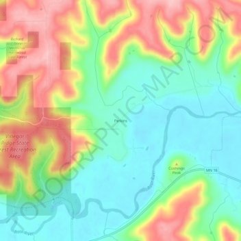
Name: Perkins topographic map, elevation, terrain.

Location: Perkins, Houston County, Minnesota, United States (43.76302 -91.66431 43.80302 -91.62431)

Average elevation: 273 m

Minimum elevation: 203 m

Maximum elevation: 377 m

Other topographic maps

Click on a map to view its topography, its elevation and its terrain.

La Crescent

United States > Minnesota > Houston County

Average elevation: 231 m

Hokah

United States > Minnesota > Houston County

Average elevation: 235 m

Eitzen

United States > Minnesota > Houston County

Average elevation: 342 m

Brownsville

United States > Minnesota > Houston County

Average elevation: 247 m

Gear up for your next adventure:

🚲Heavy Duty Bike Lock - Secure your bike at the trailhead or during stops
🧢Beanie Hat - Keep your head warm in cold weather
💡LED Camping Lantern - Illuminate your campsite with long-lasting lanterns
🧤Insulated Winter Gloves - Heavy-duty protection for sub-zero Canadian adventures
🥘Camping Cookware Set - Compact nesting pots and pans for trail cooking

As an Amazon Associate, this site earns from qualifying purchases at no extra cost to you.