Geolocate

Bee topographic map

Click on the map to display elevation.

About this map

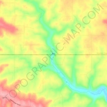
Name: Bee topographic map, elevation, terrain.

Location: Bee, Houston County, Minnesota, United States (43.48108 -91.59070 43.52108 -91.55070)

Average elevation: 324 m

Minimum elevation: 255 m

Maximum elevation: 381 m

Other topographic maps

Click on a map to view its topography, its elevation and its terrain.

La Crescent

United States > Minnesota > Houston County

Average elevation: 231 m

Hokah

United States > Minnesota > Houston County

Average elevation: 235 m

Eitzen

United States > Minnesota > Houston County

Average elevation: 342 m

Brownsville

United States > Minnesota > Houston County

Average elevation: 247 m

Gear up for your next adventure:

💡Portable Camping Lamp - Rechargeable lamp for campsite lighting
🕶️Polarized Sunglasses - Protect your eyes with durable polarized lenses
🥾Hiking Boots - Sturdy boots providing ankle support and traction on rugged trails
🧢Sun Hat - Wide-brim hat for sun protection
Lightweight Camping Tent - Portable shelter optimized for Canadian backcountry camping

As an Amazon Associate, this site earns from qualifying purchases at no extra cost to you.