
La Perrière topographic map
Click on the map to display elevation.
About this map
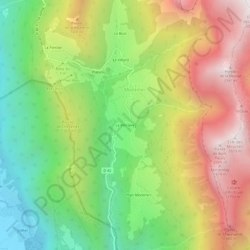
Name: La Perrière topographic map, elevation, terrain.
Average elevation: 1,163 m
Minimum elevation: 454 m
Maximum elevation: 2,018 m
Other topographic maps
Click on a map to view its topography, its elevation and its terrain.
Talloires
France > Auvergne-Rhône-Alpes > Haute-Savoie > Talloires-Montmin
Talloires se situe sur la rive Est du Lac d'Annecy, à 447 mètres d'altitude, à 13 km d'Annecy, au pied des Dents de Lanfon (1 824 m) et de la Tournette (2 351 m) point culminant du massif entourant le lac.
Average elevation: 1,044 m
Roc de Chère
France > Auvergne-Rhône-Alpes > Haute-Savoie > Talloires-Montmin
Average elevation: 488 m
Montmin
France > Auvergne-Rhône-Alpes > Haute-Savoie > Talloires-Montmin
La commune est installée à une altitude moyenne de 1 000 m au-dessus de la vallée de Faverges, qui appartient à l'ensemble plus vaste du bassin du lac d'Annecy.
Average elevation: 1,190 m