
Talloires topographic map
Click on the map to display elevation.
About this map
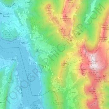
Name: Talloires topographic map, elevation, terrain.
Average elevation: 1,044 m
Minimum elevation: 446 m
Maximum elevation: 2,317 m
Other topographic maps
Click on a map to view its topography, its elevation and its terrain.
La Tournette
France > Auvergne-Rhône-Alpes > Upper Savoy > Talloires-Montmin
Average elevation: 1,750 m
Plan Montmin
France > Auvergne-Rhône-Alpes > Upper Savoy > Talloires-Montmin
Average elevation: 1,080 m