
Make a donation
Gear up for your next adventure:
As an Amazon Associate, this site earns from qualifying purchases at no extra cost to you.
Montmin topographic map
Click on the map to display elevation.
Make a donation
Gear up for your next adventure:
As an Amazon Associate, this site earns from qualifying purchases at no extra cost to you.
Montmin
La commune est installée à une altitude moyenne de 1 000 m au-dessus de la vallée de Faverges, qui appartient à l'ensemble plus vaste du bassin du lac d'Annecy.
Make a donation
Gear up for your next adventure:
As an Amazon Associate, this site earns from qualifying purchases at no extra cost to you.
About this map
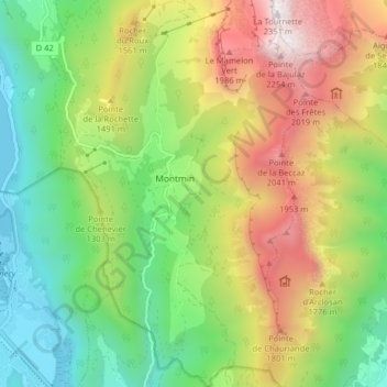
Name: Montmin topographic map, elevation, terrain.
Average elevation: 1,190 m
Minimum elevation: 447 m
Maximum elevation: 2,317 m
Make a donation
Gear up for your next adventure:
As an Amazon Associate, this site earns from qualifying purchases at no extra cost to you.
Other topographic maps
Click on a map to view its topography, its elevation and its terrain.
La Perrière
France > Auvergne-Rhône-Alpes > Haute-Savoie > Talloires-Montmin
Average elevation: 1,163 m
Rocher du Roux
France > Auvergne-Rhône-Alpes > Haute-Savoie > Talloires-Montmin
Average elevation: 1,221 m
Roc de Chère
France > Auvergne-Rhône-Alpes > Haute-Savoie > Talloires-Montmin
Average elevation: 488 m
Le Vivier
France > Auvergne-Rhône-Alpes > Haute-Savoie > Talloires-Montmin > Talloires
Average elevation: 653 m
Make a donation
Gear up for your next adventure:
As an Amazon Associate, this site earns from qualifying purchases at no extra cost to you.
Plan Montmin
France > Auvergne-Rhône-Alpes > Haute-Savoie > Talloires-Montmin
Average elevation: 1,080 m
Perroix
France > Auvergne-Rhône-Alpes > Haute-Savoie > Talloires-Montmin > Talloires
Average elevation: 694 m
Make a donation
Gear up for your next adventure:
As an Amazon Associate, this site earns from qualifying purchases at no extra cost to you.
La Sauffaz
France > Auvergne-Rhône-Alpes > Haute-Savoie > Talloires-Montmin
Average elevation: 1,007 m
La Tournette
France > Auvergne-Rhône-Alpes > Haute-Savoie > Talloires-Montmin > Le Bois
Average elevation: 1,750 m
Make a donation
Gear up for your next adventure:
As an Amazon Associate, this site earns from qualifying purchases at no extra cost to you.
Ermitage de Saint-Germain
France > Auvergne-Rhône-Alpes > Haute-Savoie > Talloires-Montmin
Average elevation: 761 m
Les Mouilles
France > Auvergne-Rhône-Alpes > Haute-Savoie > Talloires-Montmin
Average elevation: 836 m
Vérel
France > Auvergne-Rhône-Alpes > Haute-Savoie > Talloires-Montmin > Talloires
Average elevation: 882 m
Make a donation
Gear up for your next adventure:
As an Amazon Associate, this site earns from qualifying purchases at no extra cost to you.
Le Mamelon Vert
France > Auvergne-Rhône-Alpes > Haute-Savoie > Talloires-Montmin
Average elevation: 1,630 m
Le Villard
France > Auvergne-Rhône-Alpes > Haute-Savoie > Talloires-Montmin
Average elevation: 1,258 m
Écharvines
France > Auvergne-Rhône-Alpes > Haute-Savoie > Talloires-Montmin > Talloires
Average elevation: 593 m
Make a donation
Gear up for your next adventure:
As an Amazon Associate, this site earns from qualifying purchases at no extra cost to you.
Montmin
France > Auvergne-Rhône-Alpes > Haute-Savoie > Talloires-Montmin > Montmin
Average elevation: 1,279 m
Angon
France > Auvergne-Rhône-Alpes > Haute-Savoie > Talloires-Montmin > Talloires
Average elevation: 656 m