Geolocate

Testico topographic map

Click on the map to display elevation.

About this map

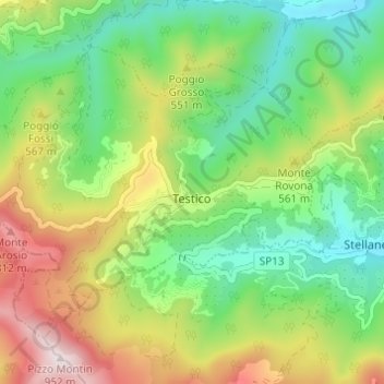
Name: Testico topographic map, elevation, terrain.

Location: Testico, Savona, Liguria, Italy (43.98969 7.98909 44.02304 8.05007)

Average elevation: 426 m

Minimum elevation: 123 m

Maximum elevation: 932 m

Other topographic maps

Click on a map to view its topography, its elevation and its terrain.

Vara Superiore

Italy > Liguria > Savona

Average elevation: 819 m

Varigotti

Italy > Liguria > Savona > Finale Ligure

Average elevation: 100 m

Montefreddo

Italy > Liguria > Savona > Mallare

Average elevation: 526 m

Praie

Italy > Liguria > Savona > Piana Crixia

Average elevation: 343 m

San Giuseppe di Cairo

Italy > Liguria > Savona > Cairo Montenotte

Average elevation: 394 m

Riofreddo

Italy > Liguria > Savona

Average elevation: 816 m

Armati

Italy > Liguria > Savona > Stellanello

Average elevation: 427 m

Villarelli

Italy > Liguria > Savona > Stellanello

Average elevation: 336 m

Perru

Italy > Liguria > Savona > Albisola Superiore

Average elevation: 368 m

Santa Giulia

Italy > Liguria > Savona > Dego

Average elevation: 550 m

Bardino Nuovo

Italy > Liguria > Savona

Average elevation: 285 m

Costa dei Ginestri

Italy > Liguria > Savona > Bergeggi

Average elevation: 81 m

Varigotti

Italy > Liguria > Savona > Finale Ligure

Average elevation: 100 m

Monte Agri

Italy > Liguria > Savona > Savona

Average elevation: 316 m

Gear up for your next adventure:

🧳Compression Sacks - Maximize space in your backpack by shrinking gear
Camping Groundsheet - Protect your tent from moisture and dirt
👖Convertible Hiking Pants - Zip-off legs to adapt to changing weather conditions
🔋Lithium AA Batteries - Long-lasting power that performs in extreme cold
💡Compact LED Flashlight - Powerful and portable flashlight for outdoor use

As an Amazon Associate, this site earns from qualifying purchases at no extra cost to you.