Geolocate

Montefreddo topographic map

Click on the map to display elevation.

About this map

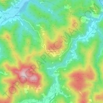
Name: Montefreddo topographic map, elevation, terrain.

Location: Montefreddo, Mallare, Savona, Liguria, 17045, Italy (44.29235 8.28024 44.33235 8.32024)

Average elevation: 526 m

Minimum elevation: 384 m

Maximum elevation: 751 m

Gear up for your next adventure:

🧭GPS Handheld Device - Reliable GPS navigation for outdoor adventures
🧣Evaporative Cooling Towel - Beat the heat during intense summer climbs
🔪Outdoor Multitool - Versatile tool for repairs and food prep in the wild
🧢Outdoor Visor - Breathable visor for sunny hikes
🥾Hiking Leggings - Comfortable leggings for outdoor activities

As an Amazon Associate, this site earns from qualifying purchases at no extra cost to you.