Geolocate

Ile Moyenne topographic map

Interactive map

Click on the map to display elevation.

About this map

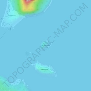
Name: Ile Moyenne topographic map, elevation, terrain.

Location: Ile Moyenne, Victoria, Seychelles (-4.62119 55.50697 -4.61798 55.51093)

Average elevation: 6 m

Minimum elevation: -1 m

Maximum elevation: 207 m

Other topographic maps

Click on a map to view its topography, its elevation and its terrain.

Saint-Anne

Seychelles > Victoria

Saint-Anne, Victoria, Seychelles

Average elevation: 15 m

Morne Seychellois

Seychelles > Victoria

Morne Seychellois, Victoria, Mahé, SEZ, Seychelles

Average elevation: 508 m

Marianne

Seychelles > Victoria

Marianne, Victoria, Seychelles

Average elevation: 4 m

Ile de Frégate

Seychelles > Victoria

Ile de Frégate, Victoria, Seychelles

Average elevation: 10 m

Aride Island

Seychelles > Victoria

Aride Island, Victoria, Seychelles

Average elevation: 3 m