Geolocate

Olena topographic map

Click on the map to display elevation.

About this map

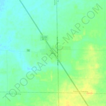
Name: Olena topographic map, elevation, terrain.

Location: Olena, Bronson Township, Huron County, Ohio, United States (41.13450 -82.56101 41.17450 -82.52101)

Average elevation: 289 m

Minimum elevation: 279 m

Maximum elevation: 304 m

Other topographic maps

Click on a map to view its topography, its elevation and its terrain.

Willard

United States > Ohio > Huron County

Average elevation: 284 m

Greenwich

United States > Ohio > Huron County

Average elevation: 317 m

North Fairfield

United States > Ohio > Huron County

Average elevation: 284 m

Plymouth

United States > Ohio > Huron County

Average elevation: 305 m

Holiday Lakes

United States > Ohio > Huron County

Average elevation: 263 m

New London Township

United States > Ohio > Huron County

Average elevation: 297 m

Wakeman

United States > Ohio > Huron County

Average elevation: 263 m

Monroeville

United States > Ohio > Huron County

Average elevation: 219 m

New London

United States > Ohio > Huron County

Average elevation: 304 m

Gear up for your next adventure:

🧥Insulated Jacket - Keep warm in cold outdoor conditions
🧥Waterproof Jacket - Lightweight rain jackets for hiking and outdoor activities
🥾Durable Hiking Shoes - Long-lasting shoes for frequent hiking
🔋Lithium AA Batteries - Long-lasting power that performs in extreme cold
❄️Traction Ice Cleats - Slip-on spikes for icy trails and winter hiking

As an Amazon Associate, this site earns from qualifying purchases at no extra cost to you.