Geolocate

Plymouth topographic map

Click on the map to display elevation.

About this map

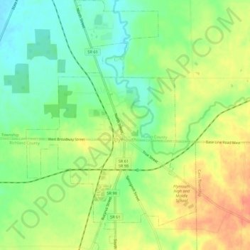
Name: Plymouth topographic map, elevation, terrain.

Location: Plymouth, New Haven Township, Huron County, Ohio, 44865, United States (40.97714 -82.68690 41.01807 -82.65015)

Average elevation: 305 m

Minimum elevation: 283 m

Maximum elevation: 329 m

Other topographic maps

Click on a map to view its topography, its elevation and its terrain.

New Haven

United States > Ohio > Huron County

Average elevation: 287 m

Boughtonville

United States > Ohio > Huron County

Average elevation: 303 m

Centerton

United States > Ohio > Huron County

Average elevation: 269 m

Delphi

United States > Ohio > Huron County

Average elevation: 314 m

East Townsend

United States > Ohio > Huron County

Average elevation: 272 m

Fitchville

United States > Ohio > Huron County

Average elevation: 298 m

Hunts Corners

United States > Ohio > Huron County

Average elevation: 235 m

Olena

United States > Ohio > Huron County

Average elevation: 289 m

Steuben

United States > Ohio > Huron County

Average elevation: 263 m

Huron Junction

United States > Ohio > Huron County > Norwalk

Average elevation: 231 m

Collins

United States > Ohio > Huron County

Average elevation: 267 m

Gear up for your next adventure:

🦌Outdoor Trail Camera - Monitor wildlife activity near your favorite spots
🧰Survival Kit - Essential gear for emergencies in the wilderness
💡LED Headlamp - Hands-free illumination for night hiking and camping
🥾Approach Shoes - Shoes designed for climbing approaches and rugged trails
🎒Hiking Backpack - Lightweight and ergonomic backpacks for day hikes or multi-day treks

As an Amazon Associate, this site earns from qualifying purchases at no extra cost to you.