
Make a donation
Gear up for your next adventure:
As an Amazon Associate, this site earns from qualifying purchases at no extra cost to you.
Minsterworth topographic map
Click on the map to display elevation.
Make a donation
Gear up for your next adventure:
As an Amazon Associate, this site earns from qualifying purchases at no extra cost to you.
About this map
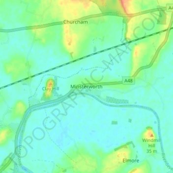
Name: Minsterworth topographic map, elevation, terrain.
Average elevation: 14 m
Minimum elevation: 4 m
Maximum elevation: 40 m
Make a donation
Gear up for your next adventure:
As an Amazon Associate, this site earns from qualifying purchases at no extra cost to you.
Other topographic maps
Click on a map to view its topography, its elevation and its terrain.
Shurdington
United Kingdom > England > Gloucestershire > Tewkesbury > Shurdington
Average elevation: 110 m
Crickley Hill and Barrow Wake
United Kingdom > England > Gloucestershire > Tewkesbury > Bentham
Average elevation: 205 m
Make a donation
Gear up for your next adventure:
As an Amazon Associate, this site earns from qualifying purchases at no extra cost to you.
Make a donation
Gear up for your next adventure:
As an Amazon Associate, this site earns from qualifying purchases at no extra cost to you.
Make a donation
Gear up for your next adventure:
As an Amazon Associate, this site earns from qualifying purchases at no extra cost to you.
Alney Island
United Kingdom > England > Gloucestershire > Tewkesbury > Maisemore
Average elevation: 13 m
Make a donation
Gear up for your next adventure:
As an Amazon Associate, this site earns from qualifying purchases at no extra cost to you.
Peak Plantation
United Kingdom > England > Gloucestershire > Tewkesbury > Witcombe
Average elevation: 217 m
Bishop's Cleeve
United Kingdom > England > Gloucestershire > Tewkesbury > Gotherington
Average elevation: 51 m
Make a donation
Gear up for your next adventure:
As an Amazon Associate, this site earns from qualifying purchases at no extra cost to you.
Make a donation
Gear up for your next adventure:
As an Amazon Associate, this site earns from qualifying purchases at no extra cost to you.
Make a donation
Gear up for your next adventure:
As an Amazon Associate, this site earns from qualifying purchases at no extra cost to you.