Geolocate

Lembang topographic map

Click on the map to display elevation.

About this map

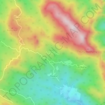
Name: Lembang topographic map, elevation, terrain.

Location: Lembang, Enrekang, South Sulawesi, Sulawesi, Indonesia (-3.57677 119.82824 -3.53677 119.86824)

Average elevation: 648 m

Minimum elevation: 355 m

Maximum elevation: 1,009 m

Other topographic maps

Click on a map to view its topography, its elevation and its terrain.

Baraka

Indonesia > South Sulawesi > Enrekang

Average elevation: 827 m

Malua

Indonesia > South Sulawesi > Enrekang

Average elevation: 709 m

Alla

Indonesia > South Sulawesi > Enrekang

Average elevation: 1,037 m

Bungin

Indonesia > South Sulawesi > Enrekang

Average elevation: 1,238 m

Cendana

Indonesia > South Sulawesi > Enrekang

Average elevation: 152 m

Maiwa

Indonesia > South Sulawesi > Enrekang

Average elevation: 214 m

Malua

Indonesia > South Sulawesi > Enrekang

Average elevation: 709 m

Buntu Batu

Indonesia > South Sulawesi > Enrekang

Average elevation: 1,459 m

Gear up for your next adventure:

🧥Waterproof Jacket - Lightweight rain jackets for hiking and outdoor activities
🛶Canoe Life Vest - Safety vest for water sports
💧Hydration Pack - Hands-free hydration system for long hikes
🦟Insect Repellent - Keep mosquitoes and black flies away in wooded areas
🧢Sun Protection Cap - Breathable cap to protect from sun exposure

As an Amazon Associate, this site earns from qualifying purchases at no extra cost to you.