Geolocate

Frumușeni topographic map

Click on the map to display elevation.

About this map

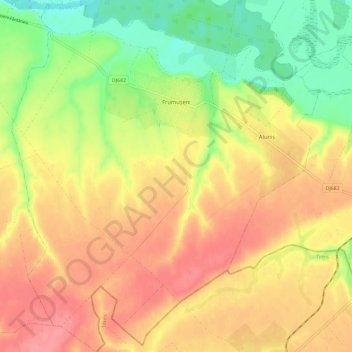
Name: Frumușeni topographic map, elevation, terrain.

Location: Frumușeni, Arad, Romania (46.04430 21.40583 46.12524 21.50792)

Average elevation: 147 m

Minimum elevation: 103 m

Maximum elevation: 182 m

Other topographic maps

Click on a map to view its topography, its elevation and its terrain.

Toc

Romania > Arad

Average elevation: 235 m

Mihaiasa

Romania > Arad > Săvârșin

Average elevation: 527 m

Munar

Romania > Arad

Average elevation: 101 m

Târnova

Romania > Arad

Average elevation: 129 m

Lupești

Romania > Arad

Average elevation: 278 m

Obârșia

Romania > Arad

Average elevation: 437 m

Munar

Romania > Arad > Munar

Average elevation: 101 m

Săvârșin

Romania > Arad

Average elevation: 217 m

Gear up for your next adventure:

🧢Sun Hat - Wide-brim hat for sun protection
🧥Fleece Jacket - Warm and lightweight jacket for layering
🧢Hiking Hat - Sun-protective and breathable hats for long treks
🦌Outdoor Trail Camera - Monitor wildlife activity near your favorite spots
💡LED Camping Lantern - Illuminate your campsite with long-lasting lanterns

As an Amazon Associate, this site earns from qualifying purchases at no extra cost to you.