
Barford topographic map
Click on the map to display elevation.
About this map
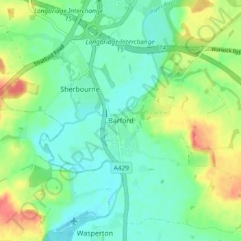
Name: Barford topographic map, elevation, terrain.
Location: Barford, Warwick, Warwickshire, England, United Kingdom (52.23364 -1.62771 52.25716 -1.56336)
Average elevation: 56 m
Minimum elevation: 39 m
Maximum elevation: 90 m
Other topographic maps
Click on a map to view its topography, its elevation and its terrain.
Rowington Green
United Kingdom > England > Warwickshire > Warwick > Rowington
Average elevation: 114 m
Hampton on the Hill
United Kingdom > England > Warwickshire > Warwick > Hampton on the Hill
Average elevation: 75 m