Geolocate

Frumușeni topographic map

Click on the map to display elevation.

About this map
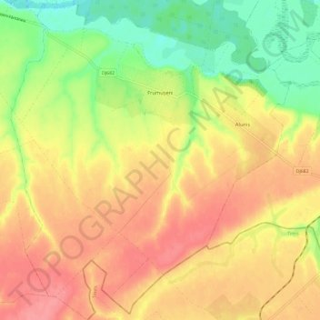
Name: Frumușeni topographic map, elevation, terrain.

Location: Frumușeni, Arad, Romania (46.04430 21.40583 46.12524 21.50792)

Average elevation: 147 m

Minimum elevation: 103 m

Maximum elevation: 182 m

Other topographic maps

Click on a map to view its topography, its elevation and its terrain.

Căprioara

Romania > Arad

Average elevation: 216 m

Brusturi

Romania > Arad

Average elevation: 514 m

Belotinț

Romania > Arad

Average elevation: 190 m

Groșii Noi

Romania > Arad

Average elevation: 282 m

Adea

Romania > Arad

Average elevation: 95 m

Mihaiasa

Romania > Arad > Săvârșin

Average elevation: 527 m

Toc

Romania > Arad

Average elevation: 235 m

Târnova

Romania > Arad

Average elevation: 129 m

Munar

Romania > Arad

Average elevation: 101 m

Lupești

Romania > Arad

Average elevation: 278 m

Munar

Romania > Arad > Munar

Average elevation: 101 m

Obârșia

Romania > Arad

Average elevation: 437 m

Gear up for your next adventure:

🧥Packable Rain Jacket - Breathable waterproof layer for unpredictable weather
🧥Thermal Fleece Jacket - Versatile insulation for changing mountain temperatures
🥾Hiking Shorts - Breathable shorts suitable for summer hikes
🥾Trail Hiking Boots - Supportive boots for rough trails
🚲MTB Frame Bag - Carry tools and maps directly on your bicycle frame

As an Amazon Associate, this site earns from qualifying purchases at no extra cost to you.