
Thank you for supporting this site ❤️
Make a donation
Make a donation
Gear up for your next adventure:
As an Amazon Associate, this site earns from qualifying purchases at no extra cost to you.
Drumay topographic map
Click on the map to display elevation.
Thank you for supporting this site ❤️
Make a donation
Make a donation
Gear up for your next adventure:
As an Amazon Associate, this site earns from qualifying purchases at no extra cost to you.
About this map
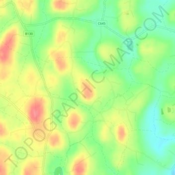
Name: Drumay topographic map, elevation, terrain.
Location: Drumay, Armagh, Northern Ireland, United Kingdom (54.43650 -6.76126 54.44598 -6.73600)
Average elevation: 58 m
Minimum elevation: 24 m
Maximum elevation: 94 m
Thank you for supporting this site ❤️
Make a donation
Make a donation
Gear up for your next adventure:
As an Amazon Associate, this site earns from qualifying purchases at no extra cost to you.