
Make a donation
Gear up for your next adventure:
As an Amazon Associate, this site earns from qualifying purchases at no extra cost to you.
Speldhurst topographic map
Click on the map to display elevation.
Make a donation
Gear up for your next adventure:
As an Amazon Associate, this site earns from qualifying purchases at no extra cost to you.
About this map
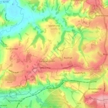
Name: Speldhurst topographic map, elevation, terrain.
Location: Speldhurst, Tunbridge Wells, Kent, England, United Kingdom (51.11541 0.15004 51.16083 0.24069)
Average elevation: 89 m
Minimum elevation: 27 m
Maximum elevation: 149 m
Make a donation
Gear up for your next adventure:
As an Amazon Associate, this site earns from qualifying purchases at no extra cost to you.
Other topographic maps
Click on a map to view its topography, its elevation and its terrain.
Make a donation
Gear up for your next adventure:
As an Amazon Associate, this site earns from qualifying purchases at no extra cost to you.
Make a donation
Gear up for your next adventure:
As an Amazon Associate, this site earns from qualifying purchases at no extra cost to you.
Chalybeate Spring
United Kingdom > England > Kent > Tunbridge Wells > Kilndown
Average elevation: 65 m
Rusthall Common Cricket Ground
United Kingdom > England > Kent > Tunbridge Wells > Rusthall
Average elevation: 99 m
Bedgebury National Pinetum
United Kingdom > England > Kent > Tunbridge Wells > Kilndown
Average elevation: 91 m
Make a donation
Gear up for your next adventure:
As an Amazon Associate, this site earns from qualifying purchases at no extra cost to you.
Make a donation
Gear up for your next adventure:
As an Amazon Associate, this site earns from qualifying purchases at no extra cost to you.
Underground reservoir
United Kingdom > England > Kent > Tunbridge Wells > Hartley > Flishinghurst
Average elevation: 103 m
Make a donation
Gear up for your next adventure:
As an Amazon Associate, this site earns from qualifying purchases at no extra cost to you.
Make a donation
Gear up for your next adventure:
As an Amazon Associate, this site earns from qualifying purchases at no extra cost to you.