Geolocate

Hungen topographic map

Click on the map to display elevation.

About this map
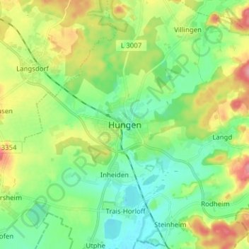
Name: Hungen topographic map, elevation, terrain.

Location: Hungen, Landkreis Gießen, Hesse, 35410, Germany (50.43525 8.86099 50.51525 8.94099)

Average elevation: 160 m

Minimum elevation: 125 m

Maximum elevation: 227 m

Other topographic maps

Click on a map to view its topography, its elevation and its terrain.

Giessen

Germany > Hesse > Landkreis Gießen

Average elevation: 204 m

Giessen

Germany > Hesse > Landkreis Gießen

Average elevation: 205 m

Gießen

Germany > Hesse > Landkreis Gießen

Average elevation: 205 m

Reiskirchen

Germany > Hesse > Landkreis Gießen

Average elevation: 244 m

Treis

Germany > Hesse > Landkreis Gießen

Average elevation: 251 m

Rodheim-Bieber

Germany > Hesse > Landkreis Gießen

Average elevation: 239 m

Buseck

Germany > Hesse > Landkreis Gießen

Average elevation: 232 m

Wieseck

Germany > Hesse > Landkreis Gießen > Gießen

Average elevation: 183 m

Langgöns

Germany > Hesse > Landkreis Gießen

Average elevation: 261 m

Wettenberg

Germany > Hesse > Landkreis Gießen

Average elevation: 233 m

Grünberg

Germany > Hesse > Landkreis Gießen

This is a scan of the historical document: Title: Grünberg - Topographia Hassiae language: German

Average elevation: 286 m

Gear up for your next adventure:

🔭Compact Monocular - One-handed bird watching and trail spotting
🧊Insulated Water Bottle - Keeps drinks cold in summer and prevents freezing in winter
🐕Hiking Dog Pack - Let your canine companion carry their own water and food
💡LED Camping Lantern - Illuminate your campsite with long-lasting lanterns
🧰Emergency Multi-Tool - Compact multi-tool for outdoor survival

As an Amazon Associate, this site earns from qualifying purchases at no extra cost to you.