Geolocate

Wettenberg topographic map

Click on the map to display elevation.

About this map

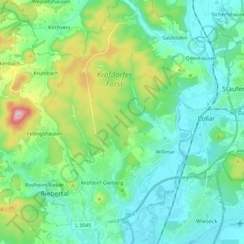
Name: Wettenberg topographic map, elevation, terrain.

Location: Wettenberg, Landkreis Gießen, Hesse, 35435, Germany (50.59547 8.59969 50.69910 8.69658)

Average elevation: 233 m

Minimum elevation: 153 m

Maximum elevation: 500 m

Other topographic maps

Click on a map to view its topography, its elevation and its terrain.

Spitze

Germany > Hesse > Landkreis Gießen > Annerod

Average elevation: 249 m

Hungen

Germany > Hesse > Landkreis Gießen

Average elevation: 160 m

Lich

Germany > Hesse > Landkreis Gießen > Lich > Lich

Average elevation: 200 m

Gear up for your next adventure:

🥾Waterproof Hiking Boots - Essential footwear for rugged terrain and wet Canadian trails
🧶550 Survival Paracord - Versatile utility cord for emergency repairs and rigging
🚲Handlebar Phone Mount - View topographic-map.com live while cycling
👟Trail Running Shoes - Agile footwear for fast-paced topographic exploration
🥾Mountain Hiking Shoes - Shoes with superior grip for mountainous terrain

As an Amazon Associate, this site earns from qualifying purchases at no extra cost to you.