
Make a donation
Gear up for your next adventure:
As an Amazon Associate, this site earns from qualifying purchases at no extra cost to you.
Grünberg topographic map
Click on the map to display elevation.
Make a donation
Gear up for your next adventure:
As an Amazon Associate, this site earns from qualifying purchases at no extra cost to you.
Grünberg
This is a scan of the historical document: Title: Grünberg - Topographia Hassiae language: German
Make a donation
Gear up for your next adventure:
As an Amazon Associate, this site earns from qualifying purchases at no extra cost to you.
About this map
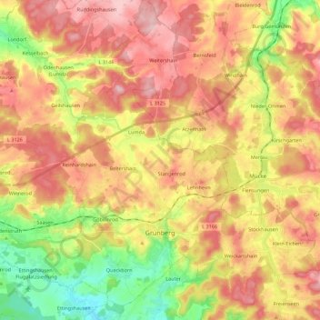
Name: Grünberg topographic map, elevation, terrain.
Location: Grünberg, Landkreis Gießen, Hesse, 35305, Germany (50.55548 8.84987 50.69025 9.06949)
Average elevation: 286 m
Minimum elevation: 185 m
Maximum elevation: 371 m
Make a donation
Gear up for your next adventure:
As an Amazon Associate, this site earns from qualifying purchases at no extra cost to you.
Other topographic maps
Click on a map to view its topography, its elevation and its terrain.