
Town of Slave Lake topographic map
Interactive map
Click on the map to display elevation.
About this map
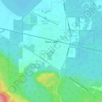
Name: Town of Slave Lake topographic map, elevation, terrain.
Average elevation: 589 m
Minimum elevation: 572 m
Maximum elevation: 693 m
Other topographic maps
Click on a map to view its topography, its elevation and its terrain.
Horseshoe Lake
Canada > Alberta > Municipal District of Lesser Slave River
Horseshoe Lake, Municipal District of Lesser Slave River, Alberta, Canada
Average elevation: 617 m
Dancing Lake
Canada > Alberta > Municipal District of Lesser Slave River
Dancing Lake, Municipal District of Lesser Slave River, Alberta, Canada
Average elevation: 684 m