
Make a donation
Gear up for your next adventure:
As an Amazon Associate, this site earns from qualifying purchases at no extra cost to you.
East topographic map
Click on the map to display elevation.
Make a donation
Gear up for your next adventure:
As an Amazon Associate, this site earns from qualifying purchases at no extra cost to you.
East
Almost the entire territory of the East Region lies on the South Cameroon Plateau that forms the southeastern half of the country. The elevation thus varies between 500 and 1000 metres above sea level except for lower-lying plains of 200 to 500 metres in the extreme southeast centered on the Dja, Boumba, Sangha, and Ngoko Rivers. The land consists largely of monotonous, gently undulating hills known as "half-oranges" due to their resemblance to that fruit.
Make a donation
Gear up for your next adventure:
As an Amazon Associate, this site earns from qualifying purchases at no extra cost to you.
About this map
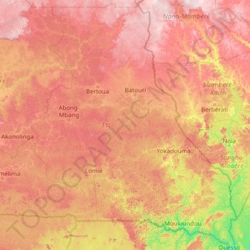
Name: East topographic map, elevation, terrain.
Location: East, Cameroon (1.65179 12.49414 6.12910 16.19110)
Average elevation: 643 m
Minimum elevation: 330 m
Maximum elevation: 1,149 m
Make a donation
Gear up for your next adventure:
As an Amazon Associate, this site earns from qualifying purchases at no extra cost to you.
Other topographic maps
Click on a map to view its topography, its elevation and its terrain.
Make a donation
Gear up for your next adventure:
As an Amazon Associate, this site earns from qualifying purchases at no extra cost to you.
Make a donation
Gear up for your next adventure:
As an Amazon Associate, this site earns from qualifying purchases at no extra cost to you.