
Thank you for supporting this site ❤️
Make a donation
Make a donation
Gear up for your next adventure:
As an Amazon Associate, this site earns from qualifying purchases at no extra cost to you.
Manengouba topographic map
Click on the map to display elevation.
Thank you for supporting this site ❤️
Make a donation
Make a donation
Gear up for your next adventure:
As an Amazon Associate, this site earns from qualifying purchases at no extra cost to you.
About this map
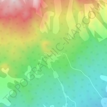
Name: Manengouba topographic map, elevation, terrain.
Location: Manengouba, Ebone, Moungo, Littoral, Cameroon (4.93499 9.84513 4.97499 9.88513)
Average elevation: 1,127 m
Minimum elevation: 880 m
Maximum elevation: 1,514 m
Thank you for supporting this site ❤️
Make a donation
Make a donation
Gear up for your next adventure:
As an Amazon Associate, this site earns from qualifying purchases at no extra cost to you.