
Scalloway topographic map
Click on the map to display elevation.
About this map
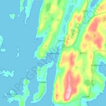
Name: Scalloway topographic map, elevation, terrain.
Location: Scalloway, Shetland, Scotland, ZE1 0XT, United Kingdom (60.09714 -1.31527 60.17714 -1.23527)
Average elevation: 43 m
Minimum elevation: -13 m
Maximum elevation: 213 m
Other topographic maps
Click on a map to view its topography, its elevation and its terrain.
Lerwick
United Kingdom > Scotland > Shetland
Lerwick has transitioned from a subpolar oceanic climate (Cfc) to a maritime climate (Cfb) with cool to cold temperatures all year long. The lack of trees reflects the latter type. This is particularly pronounced by virtue of Lerwick being on the coast of an island, so even extreme temperature records are…
Average elevation: 34 m
Yell
United Kingdom > Scotland > Shetland
Yell is 19 miles (31 kilometres) in length, with a maximum breadth of 7.5 miles (12.1 kilometres), and is swept all around by very impetuous tides. The island extends northward to within 9.5 miles (15.3 kilometres) of the northwestern extremity of Unst. It is divided by only the narrow Bluemull Sound from the…
Average elevation: 27 m
Out Skerries
United Kingdom > Scotland > Shetland
Being so close to Norway, the islands were of strategic importance in World War II and were a regular landfall for Norwegian boats carrying escapees from the Nazi occupation. The local coastguard was responsible for the refugees, and at one point during the war were issued with a tommy gun, although initially…
Average elevation: 1 m
Housay
United Kingdom > Scotland > Shetland
Being so close to Norway, the islands were of strategic importance in World War II and were a regular landfall for Norwegian boats carrying escapees from the Nazi occupation. The local coastguard was responsible for the refugees, and at one point during the war were issued with a tommy gun, although initially…
Average elevation: 3 m