Geolocate

Storey County topographic map

Click on the map to display elevation.

About this map

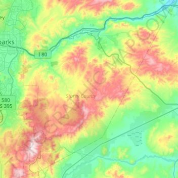
Name: Storey County topographic map, elevation, terrain.

Location: Storey County, Nevada, United States (39.25087 -119.71446 39.62889 -119.27980)

Average elevation: 1,596 m

Minimum elevation: 1,238 m

Maximum elevation: 2,361 m

Other topographic maps

Click on a map to view its topography, its elevation and its terrain.

Railroad Valley

United States > Nevada

Average elevation: 1,912 m

Triangle Mountain

United States > Nevada > Nye County

Average elevation: 1,751 m

Crescent Dunes

United States > Nevada > Nye County

Average elevation: 1,584 m

Pleasant Valley

United States > Nevada > Washoe County

Average elevation: 1,587 m

Ryndon

United States > Nevada > Elko County

Average elevation: 1,603 m

Downeyville

United States > Nevada > Nye County

Average elevation: 1,491 m

Smith

United States > Nevada > Lyon County

Average elevation: 1,461 m

Groom Lake

United States > Nevada > Lincoln County

Average elevation: 1,355 m

Silver Peak

United States > Nevada > Esmeralda County

Average elevation: 1,350 m

Henderson

United States > Nevada > Clark County > Henderson

Average elevation: 662 m

Holborn

United States > Nevada > Elko County > Holborn

Average elevation: 1,855 m

Gear up for your next adventure:

🧢Outdoor Visor - Breathable visor for sunny hikes
🐕Hiking Dog Pack - Let your canine companion carry their own water and food
🔥Camping Stove - Portable stoves to cook outdoors with ease
🎒Hiking Backpack - Lightweight and ergonomic backpacks for day hikes or multi-day treks
🪑Insulated Seat Pad - Protect your seat from cold rocks and wet logs

As an Amazon Associate, this site earns from qualifying purchases at no extra cost to you.