
Tablas Island topographic map
Interactive map
Click on the map to display elevation.
About this map
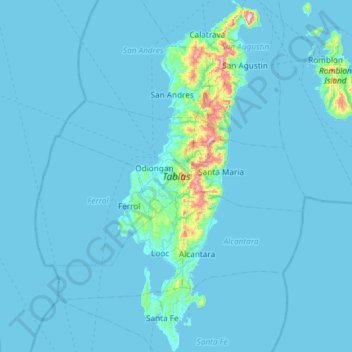
Name: Tablas Island topographic map, elevation, terrain.
Location: Tablas Island, Looc, Romblon, Mimaropa, Philippinen (12.09910 121.91995 12.67484 122.16231)
Average elevation: 26 m
Minimum elevation: -1 m
Maximum elevation: 658 m
Other topographic maps
Click on a map to view its topography, its elevation and its terrain.