Geolocate

Alstone topographic map

Click on the map to display elevation.

About this map

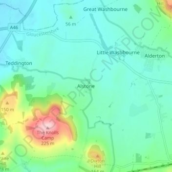
Name: Alstone topographic map, elevation, terrain.

Location: Alstone, Tewkesbury, Gloucestershire, England, GL20 8JD, United Kingdom (51.97060 -2.04604 52.01060 -2.00604)

Average elevation: 68 m

Minimum elevation: 24 m

Maximum elevation: 221 m

Other topographic maps

Click on a map to view its topography, its elevation and its terrain.

Gretton

United Kingdom > England > Gloucestershire > Tewkesbury

Average elevation: 100 m

Stanway

United Kingdom > England > Gloucestershire > Tewkesbury > Stanway

Average elevation: 170 m

Norton

United Kingdom > England > Gloucestershire > Tewkesbury

Average elevation: 18 m

Twyning

United Kingdom > England > Gloucestershire > Tewkesbury

Average elevation: 22 m

Snowshill

United Kingdom > England > Gloucestershire > Tewkesbury

Average elevation: 249 m

Snowshill

United Kingdom > England > Gloucestershire > Tewkesbury

Average elevation: 249 m

Hawling

United Kingdom > England > Gloucestershire > Tewkesbury

Average elevation: 241 m

Hasfield

United Kingdom > England > Gloucestershire > Tewkesbury

Average elevation: 21 m

Tirley

United Kingdom > England > Gloucestershire > Tewkesbury

Average elevation: 19 m

Northway

United Kingdom > England > Gloucestershire > Tewkesbury

Average elevation: 21 m

Twyning

United Kingdom > England > Gloucestershire > Tewkesbury

Average elevation: 22 m

Gear up for your next adventure:

🕶️Polarized Sunglasses - Reduces glare from snow and water at high elevations
🍽️Titanium Camping Spork - Ultralight and indestructible eating utensil
🛌Insulated Sleeping Pad - Critical thermal barrier between you and the cold ground
🔦LED Flashlight - Powerful and long-lasting flashlight for camping and emergencies
🏃Hydration Running Vest - Carry water and maps close to your body for speed

As an Amazon Associate, this site earns from qualifying purchases at no extra cost to you.