Geolocate

Juli topographic map

Click on the map to display elevation.

About this map

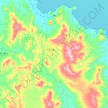
Name: Juli topographic map, elevation, terrain.

Location: Juli, Province of Chucuito, Puno, Peru (-16.49876 -69.68792 -16.17421 -69.32969)

Average elevation: 4,064 m

Minimum elevation: 3,807 m

Maximum elevation: 4,689 m

Other topographic maps

Click on a map to view its topography, its elevation and its terrain.

Allin Qhapaq

Peru > Puno > Macusani

Average elevation: 5,325 m

Luquina Chico

Peru > Puno

Average elevation: 3,865 m

Chillihua

Peru > Puno > Nuñoa

Average elevation: 4,610 m

Arica

Peru > Puno > San Gabán

Average elevation: 1,032 m

Macusani

Peru > Puno > Macusani

Average elevation: 4,508 m

Cunurana

Peru > Puno > Santa Rosa

Average elevation: 4,912 m

Ananta

Peru > Puno > Ituata > Ananta

Average elevation: 4,645 m

Juliaca

Peru > Puno > Juliaca

Average elevation: 3,861 m

San Fracisco

Peru > Puno > Putina

Average elevation: 3,902 m

Saman

Peru > Puno > Samán

Average elevation: 3,824 m

Gear up for your next adventure:

🔋Emergency Crank Radio - Weather alerts and power without needing batteries
📷Outdoor Action Camera - Capture high-elevation views and rugged adventures
🦶Hiking Shoe Insoles - Added support for high arches and long days on feet
Camping Coffee Maker - Brew fresh coffee anywhere on the topographic map
🦌Outdoor Trail Camera - Monitor wildlife activity near your favorite spots

As an Amazon Associate, this site earns from qualifying purchases at no extra cost to you.