Geolocate

Peace Valley topographic map

Click on the map to display elevation.

About this map

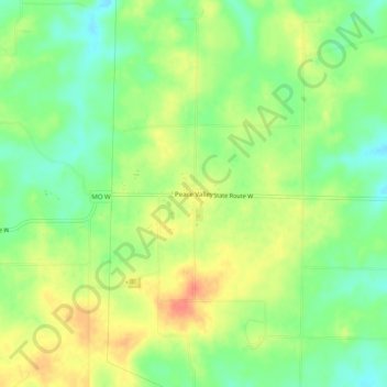
Name: Peace Valley topographic map, elevation, terrain.

Location: Peace Valley, Howell County, Missouri, United States (36.81978 -91.76641 36.85978 -91.72641)

Average elevation: 322 m

Minimum elevation: 298 m

Maximum elevation: 349 m

Other topographic maps

Click on a map to view its topography, its elevation and its terrain.

West Plains

United States > Missouri > Howell County

Average elevation: 321 m

Mountain View

United States > Missouri > Howell County

Average elevation: 362 m

West Plains

United States > Missouri > Howell County

Average elevation: 321 m

Gear up for your next adventure:

🔭Compact Monocular - One-handed bird watching and trail spotting
🚲MTB Frame Bag - Carry tools and maps directly on your bicycle frame
🧴Bear Spray Holster - Quick-access carry for essential Canadian wilderness safety
🧥Thermal Layer - Insulating layer for cold outdoor conditions
🔦LED Headtorch - Bright and durable light for night activities

As an Amazon Associate, this site earns from qualifying purchases at no extra cost to you.