Geolocate

West Plains topographic map

Click on the map to display elevation.

About this map

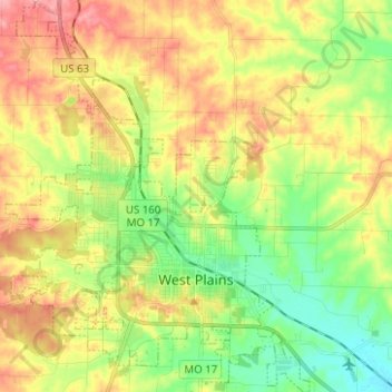
Name: West Plains topographic map, elevation, terrain.

Location: West Plains, Howell County, Missouri, 65775, United States (36.69946 -91.91329 36.79951 -91.81641)

Average elevation: 321 m

Minimum elevation: 273 m

Maximum elevation: 379 m

Other topographic maps

Click on a map to view its topography, its elevation and its terrain.

Peace Valley

United States > Missouri > Howell County

Average elevation: 322 m

Caulfield

United States > Missouri > Howell County

Average elevation: 309 m

Gear up for your next adventure:

🥾Trail Hiking Socks - Comfortable socks to prevent blisters and fatigue
🥾Waterproof Hiking Boots - Essential footwear for rugged terrain and wet Canadian trails
Camping Groundsheet - Protect your tent from moisture and dirt
🧦Thermal Socks - Warm socks for winter hiking or camping
🦶Anti-Blister Balm - Prevents friction and hotspots during long ascents

As an Amazon Associate, this site earns from qualifying purchases at no extra cost to you.