
Union City topographic map
Interactive map
Click on the map to display elevation.
About this map
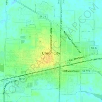
Name: Union City topographic map, elevation, terrain.
Location: Union City, Randolph County, Indiana, United States (40.18922 -84.83822 40.21577 -84.80568)
Average elevation: 333 m
Minimum elevation: 324 m
Maximum elevation: 348 m
Other topographic maps
Click on a map to view its topography, its elevation and its terrain.
Parker City
United States > Indiana > Randolph County
Parker City, Randolph County, Indiana, 47368, United States
Average elevation: 312 m
Windsor
United States > Indiana > Randolph County
Windsor, Randolph County, Indiana, 47368, United States
Average elevation: 312 m
Farmland
United States > Indiana > Randolph County
Farmland, Randolph County, Indiana, United States
Average elevation: 318 m
Lynn
United States > Indiana > Randolph County
Lynn, Randolph County, Indiana, United States
Average elevation: 356 m
Modoc
United States > Indiana > Randolph County
Modoc, Randolph County, Indiana, United States
Average elevation: 355 m
Winchester
United States > Indiana > Randolph County
Winchester, Randolph County, Indiana, 47494, United States
Average elevation: 335 m