
Tijeras topographic map
Click on the map to display elevation.
About this map
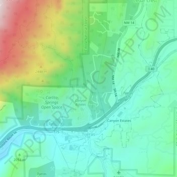
Name: Tijeras topographic map, elevation, terrain.
Average elevation: 2,038 m
Minimum elevation: 1,864 m
Maximum elevation: 2,475 m
Other topographic maps
Click on a map to view its topography, its elevation and its terrain.
Albuquerque
United States > New Mexico > Bernalillo County
Albuquerque is located in north-central New Mexico. To its east are the Sandia–Manzano Mountains. The Rio Grande flows north to south through its center, while the West Mesa and Petroglyph National Monument make up the western part of the city. Albuquerque has one of the highest elevations of any major city…
Average elevation: 1,671 m
Sandia Mountains Historical Marker
United States > New Mexico > Bernalillo County
Average elevation: 2,938 m
Eastrange-Piedra Vista
United States > New Mexico > Bernalillo County > Albuquerque
Average elevation: 1,839 m
Sandia Crest
United States > New Mexico > Bernalillo County
The Sandias are the highest range in the immediate vicinity, and are well-separated from the higher Sangre de Cristo Mountains. This gives Sandia Crest a relatively high topographic prominence of 4,098 ft (1,249 m). Lying to the east and northeast of the Sandias are two smaller ranges, the Ortiz Mountains and…
Average elevation: 2,925 m
Albuquerque
United States > New Mexico > Bernalillo County
Albuquerque is located in north-central New Mexico. To its east are the Sandia–Manzano Mountains. The Rio Grande flows north to south through its center, while the West Mesa and Petroglyph National Monument make up the western part of the city. Albuquerque has one of the highest elevations of any major city…
Average elevation: 1,671 m
Sandia Heights
United States > New Mexico > Bernalillo County > Albuquerque
Average elevation: 1,898 m
Vista Del Mundo
United States > New Mexico > Bernalillo County > Albuquerque
Average elevation: 1,903 m
Albuquerque
United States > New Mexico > Bernalillo County
Albuquerque is located in north-central New Mexico. To its east are the Sandia–Manzano Mountains. The Rio Grande flows north to south through its center, while the West Mesa and Petroglyph National Monument make up the western part of the city. Albuquerque has one of the highest elevations of any major city…
Average elevation: 1,671 m
Winterwood Park (HOA)
United States > New Mexico > Bernalillo County > Albuquerque
Average elevation: 1,770 m
Monte Largo Hills
United States > New Mexico > Bernalillo County > Albuquerque
Average elevation: 1,817 m
Glenwood Hills
United States > New Mexico > Bernalillo County > Albuquerque
Average elevation: 1,937 m
Joe M. Lucero Hillside
United States > New Mexico > Bernalillo County > Albuquerque
Average elevation: 1,637 m