Make a donation
Gear up for your next adventure:
As an Amazon Associate, this site earns from qualifying purchases at no extra cost to you.
Bicknacre topographic map
Click on the map to display elevation.
Make a donation
Gear up for your next adventure:
As an Amazon Associate, this site earns from qualifying purchases at no extra cost to you.
About this map
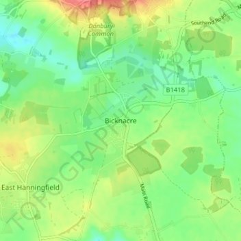
Name: Bicknacre topographic map, elevation, terrain.
Location: Bicknacre, Chelmsford, Essex, England, CM3 4EY, United Kingdom (51.67348 0.56455 51.71348 0.60455)
Average elevation: 54 m
Minimum elevation: 30 m
Maximum elevation: 93 m
Make a donation
Gear up for your next adventure:
As an Amazon Associate, this site earns from qualifying purchases at no extra cost to you.
Other topographic maps
Click on a map to view its topography, its elevation and its terrain.
Make a donation
Gear up for your next adventure:
As an Amazon Associate, this site earns from qualifying purchases at no extra cost to you.
Hanningfield Reservoir
United Kingdom > England > Essex > Chelmsford > South Hanningfield
Average elevation: 56 m
Make a donation
Gear up for your next adventure:
As an Amazon Associate, this site earns from qualifying purchases at no extra cost to you.
Make a donation
Gear up for your next adventure:
As an Amazon Associate, this site earns from qualifying purchases at no extra cost to you.
South Hanningfield
United Kingdom > England > Essex > Chelmsford > Ramsden Heath
Average elevation: 57 m
