
Make a donation
Gear up for your next adventure:
As an Amazon Associate, this site earns from qualifying purchases at no extra cost to you.
Almaty Region topographic map
Click on the map to display elevation.
Make a donation
Gear up for your next adventure:
As an Amazon Associate, this site earns from qualifying purchases at no extra cost to you.
About this map
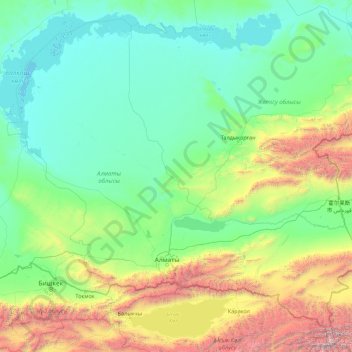
Name: Almaty Region topographic map, elevation, terrain.
Location: Almaty Region, Kazakhstan (42.21084 73.72202 46.73814 80.80728)
Average elevation: 1,137 m
Minimum elevation: 335 m
Maximum elevation: 7,318 m
Make a donation
Gear up for your next adventure:
As an Amazon Associate, this site earns from qualifying purchases at no extra cost to you.
Other topographic maps
Click on a map to view its topography, its elevation and its terrain.
Қарғалы
Kazakhstan > Almaty Region > Zhambyl District > Каргалинский сельский округ
Average elevation: 1,019 m
Make a donation
Gear up for your next adventure:
As an Amazon Associate, this site earns from qualifying purchases at no extra cost to you.
Qorğaljın
Kazakhstan > Akmola Region > Qorğaljın district
The village is located on the Kazakh Uplands. The average altitude in the village is about 330 meters above sea level. The terrain is a continuous plain with small hills and water areas.
Average elevation: 331 m
Make a donation
Gear up for your next adventure:
As an Amazon Associate, this site earns from qualifying purchases at no extra cost to you.