Geolocate

Oakham topographic map

Click on the map to display elevation.

About this map

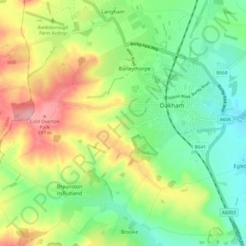
Name: Oakham topographic map, elevation, terrain.

Location: Oakham, Rutland, England, United Kingdom (52.65010 -0.79453 52.68328 -0.70559)

Average elevation: 132 m

Minimum elevation: 85 m

Maximum elevation: 204 m

Gear up for your next adventure:

🚑Survival Whistle - Signal for help across long distances in mountains
Lightweight Camping Tent - Portable shelter optimized for Canadian backcountry camping
🥾Approach Boots - Comfortable boots for hiking and climbing approaches
🥾Light Trekking Boots - Supportive boots for multi-day treks
🛌Down Sleeping Bag - Superior warmth-to-weight ratio for cold nights

As an Amazon Associate, this site earns from qualifying purchases at no extra cost to you.