Geolocate

Tallu Bamba topographic map

Click on the map to display elevation.

About this map

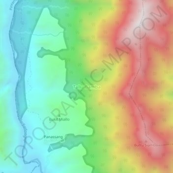
Name: Tallu Bamba topographic map, elevation, terrain.

Location: Tallu Bamba, Enrekang, South Sulawesi, Sulawesi, Indonesia (-3.42626 119.69280 -3.38626 119.73280)

Average elevation: 608 m

Minimum elevation: 107 m

Maximum elevation: 1,349 m

Other topographic maps

Click on a map to view its topography, its elevation and its terrain.

Malua

Indonesia > South Sulawesi > Enrekang

Average elevation: 709 m

Alla

Indonesia > South Sulawesi > Enrekang

Average elevation: 1,037 m

Baraka

Indonesia > South Sulawesi > Enrekang

Average elevation: 827 m

Bungin

Indonesia > South Sulawesi > Enrekang

Average elevation: 1,238 m

Cendana

Indonesia > South Sulawesi > Enrekang

Average elevation: 152 m

Maiwa

Indonesia > South Sulawesi > Enrekang

Average elevation: 214 m

Malua

Indonesia > South Sulawesi > Enrekang

Average elevation: 709 m

Buntu Batu

Indonesia > South Sulawesi > Enrekang

Average elevation: 1,459 m

Gear up for your next adventure:

🥾Trail Hiking Boots - Supportive boots for rough trails
🪑Ultralight Camping Stool - Compact seating for rest stops during long hikes
🔥Camping Stove - Portable stoves to cook outdoors with ease
💧Hydration Pack - Hands-free hydration system for long hikes
Bushcraft Tarp - Versatile emergency shelter or gear protection

As an Amazon Associate, this site earns from qualifying purchases at no extra cost to you.