Geolocate

Maroño topographic map

Click on the map to display elevation.

About this map

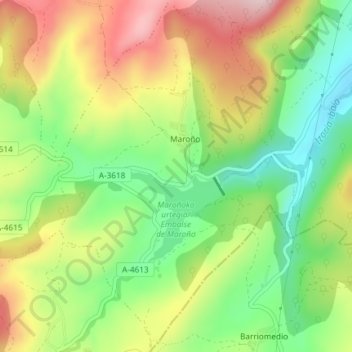
Name: Maroño topographic map, elevation, terrain.

Location: Maroño, Ayala, Álava, País Vasco, España (43.03560 -3.07228 43.06221 -3.04742)

Average elevation: 375 m

Minimum elevation: 245 m

Maximum elevation: 533 m

Other topographic maps

Click on a map to view its topography, its elevation and its terrain.

Erbi

España > País Vasco > Ayala

Average elevation: 402 m

Etxaurren

España > País Vasco > Ayala > Menoio

Average elevation: 442 m

Respaldiza

España > País Vasco > Ayala

Average elevation: 318 m

Artómaña

España > País Vasco > Ayala > Amurrio

Average elevation: 418 m

Gear up for your next adventure:

🎒Hiking Backpack - Lightweight and ergonomic backpacks for day hikes or multi-day treks
Lightweight Camping Tent - Portable shelter optimized for Canadian backcountry camping
🪑Ultralight Camping Stool - Compact seating for rest stops during long hikes
🛶Canoe Life Vest - Safety vest for water sports
🥾Waterproof Hiking Shoes - Durable shoes for wet and rugged trails

As an Amazon Associate, this site earns from qualifying purchases at no extra cost to you.