Geolocate

Pennapiedimonte topographic map

Click on the map to display elevation.

About this map

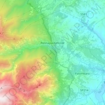
Name: Pennapiedimonte topographic map, elevation, terrain.

Location: Pennapiedimonte, Chieti, Abruzzo, Italy (42.10616 14.11039 42.18101 14.23646)

Average elevation: 886 m

Minimum elevation: 191 m

Maximum elevation: 2,724 m

Other topographic maps

Click on a map to view its topography, its elevation and its terrain.

Vallone di Santo Spirito

Italy > Abruzzo > Chieti > Fara San Martino

Average elevation: 1,273 m

Buonanotte

Italy > Abruzzo > Chieti > Vasto

Average elevation: 43 m

Fallascoso

Italy > Abruzzo > Chieti > Torricella Peligna

Average elevation: 839 m

Casali

Italy > Abruzzo > Chieti > Schiavi di Abruzzo

Average elevation: 734 m

Coderuto

Italy > Abruzzo > Chieti > Torrevecchia Teatina

Average elevation: 77 m

Foro

Italy > Abruzzo > Chieti > Miglianico

Average elevation: 143 m

Aquilano

Italy > Abruzzo > Chieti > Ortona > Aquilano

Average elevation: 86 m

Gear up for your next adventure:

💡Portable Camping Lamp - Rechargeable lamp for campsite lighting
🧤Insulated Winter Gloves - Heavy-duty protection for sub-zero Canadian adventures
🥾Waterproof Trail Shoes - Shoes designed to handle wet terrain
Camping Essentials - All-in-one gear for a comfortable camping trip
🥾Trekking Poles - Adjustable trekking poles to reduce knee stress and improve stability

As an Amazon Associate, this site earns from qualifying purchases at no extra cost to you.