Geolocate

Sverdrup Ø topographic map

Interactive map

Click on the map to display elevation.

About this map

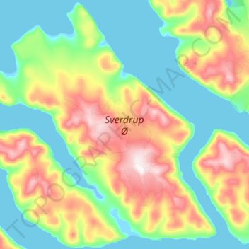
Name: Sverdrup Ø topographic map, elevation, terrain.

Location: Sverdrup Ø, Groenlandia (82.78471 -47.66110 83.03876 -45.57656)

Average elevation: 229 m

Minimum elevation: -5 m

Maximum elevation: 1,031 m

Other topographic maps

Click on a map to view its topography, its elevation and its terrain.

Isla Traill

Groenlandia

Isla Traill, Sermersooq, Groenlandia

Average elevation: 241 m

Kuhn Ø

Groenlandia

Kuhn Ø, Sermersooq, Groenlandia

Average elevation: 185 m

Store Koldewey

Groenlandia

Store Koldewey, Sermersooq, Groenlandia

Average elevation: 40 m

Milne Land

Groenlandia

Milne Land, Sermersooq, Groenlandia

Average elevation: 39 m

Clavering Ø

Groenlandia

Clavering Ø, Sermersooq, Groenlandia

Average elevation: 381 m

Ymer Ø

Groenlandia

Ymer Ø, Sermersooq, Groenlandia

Average elevation: 622 m