Geolocate

Ymer Ø topographic map

Interactive map

Click on the map to display elevation.

About this map

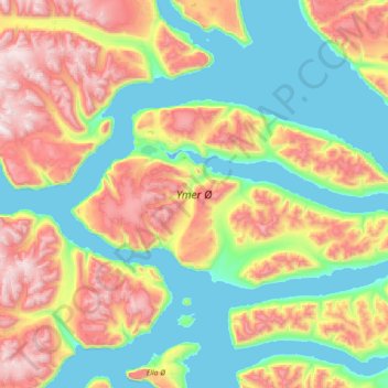
Name: Ymer Ø topographic map, elevation, terrain.

Location: Ymer Ø, Sermersooq, Groenlandia (73.02216 -25.75969 73.43278 -22.86959)

Average elevation: 622 m

Minimum elevation: -4 m

Maximum elevation: 2,298 m

Other topographic maps

Click on a map to view its topography, its elevation and its terrain.

Isla Traill

Groenlandia

Isla Traill, Sermersooq, Groenlandia

Average elevation: 241 m

Kuhn Ø

Groenlandia

Kuhn Ø, Sermersooq, Groenlandia

Average elevation: 185 m

Store Koldewey

Groenlandia

Store Koldewey, Sermersooq, Groenlandia

Average elevation: 40 m

Milne Land

Groenlandia

Milne Land, Sermersooq, Groenlandia

Average elevation: 39 m

Clavering Ø

Groenlandia

Clavering Ø, Sermersooq, Groenlandia

Average elevation: 381 m

Sverdrup Ø

Groenlandia

Sverdrup Ø, Groenlandia

Average elevation: 229 m