Geolocate

Kuhn Ø topographic map

Interactive map

Click on the map to display elevation.

About this map

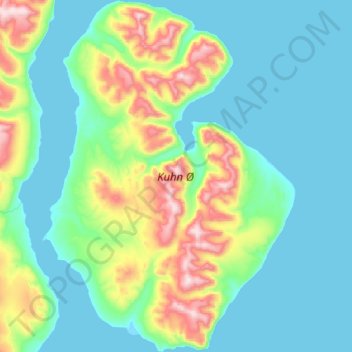
Name: Kuhn Ø topographic map, elevation, terrain.

Location: Kuhn Ø, Sermersooq, Groenlandia (74.70277 -20.66947 75.04135 -19.73459)

Average elevation: 185 m

Minimum elevation: 0 m

Maximum elevation: 1,108 m

Other topographic maps

Click on a map to view its topography, its elevation and its terrain.

Isla Traill

Groenlandia

Isla Traill, Sermersooq, Groenlandia

Average elevation: 241 m

Store Koldewey

Groenlandia

Store Koldewey, Sermersooq, Groenlandia

Average elevation: 40 m

Milne Land

Groenlandia

Milne Land, Sermersooq, Groenlandia

Average elevation: 39 m

Clavering Ø

Groenlandia

Clavering Ø, Sermersooq, Groenlandia

Average elevation: 381 m

Sverdrup Ø

Groenlandia

Sverdrup Ø, Groenlandia

Average elevation: 229 m

Ymer Ø

Groenlandia

Ymer Ø, Sermersooq, Groenlandia

Average elevation: 622 m